Last time: Introduction, planning, and the joy of cheap beer - links to all of my trip logs
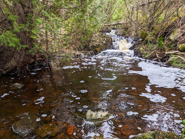 |
| A pretty waterfall near Huginnin Cove campground |
Tuesday May 23, 2023: We woke up at 5:30 am, with the sky already beginning to lighten. After a quick and mostly adequate breakfast from the hotel, we enjoyed our last showers for a week, put the last few items in our packs, and headed out.
We drove through the familiar streets of Hancock and east through Ripley to the Isle Royale Seaplane dock along Portage lake. An attendant came up to us right as we pulled in, directing us to unload our packs and then move our car back to their long-term parking lot.
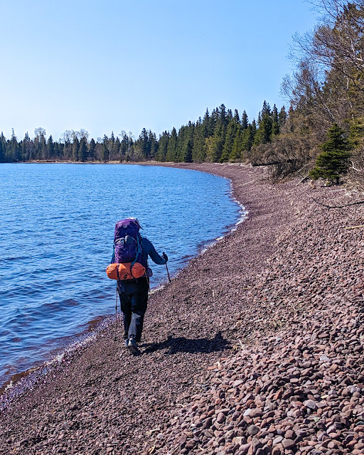
The poor woman manning the tiny booth at the seaplane dock was frazzled. Flights had only been going to the island for a couple days so far this year, a plane had broken down on the island a few days earlier, and computers weren't working. She told us all of this as she efficiently gave us directions and weighed our packs (ours each came in at about 35 lbs).
Most of the people waiting to fly left on the first plane of the day, headed to Rock Harbor on the east end of the island. We had only one other passenger on our flight to Windigo on the west end, a fellow who was arriving early before the rest of his group flew in later.
Pilot Abby greeted us at the dock and gave us a clear, no-nonsense orientation (including warning us about bumping our head on the low wing, which I immediately did). We climbed aboard the plane, strapped in, and were taxiing down the Portage in minutes.
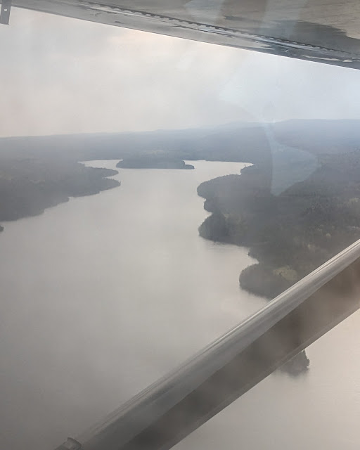 |
| Washington Harbor from the seaplane |
The day was cool and a bit hazy. Due to an unusual east wind, we took off away from the Lift Bridge -- I'd been hoping that we would fly right over it. Likewise, due to the haze, I could only make out the general shape of the land below us. Nonetheless, the ride was amazingly smooth, and we had an easy landing in Washington Harbor 30 minutes later, at 8:30 am. Pilot Abby had the plane turned around within minutes after we were unloaded, heading back to pick up another group. We immediately agreed that the seaplane was the way to get to the island.
The seaplane dock at Washington Harbor is a short walk away from "downtown" Windigo, the park's center of operations on the west end of the island. We hefted our super-full backpacks and walked to the visitor center's deck, where an enthusiastic ranger greeted us and pointed us at a small table where we were to self register. She then said "we're inside if you need help" and disappeared.
Mildly confused, I picked up a form -- the same one that I've seen a ranger fill out in front of me several times before -- and filled it out myself with our intended itinerary. I put some carbon copies in a dropbox. Nobody checked our itinerary, gave us any kind of orientation, or verified that we'd paid our permit fees.
We did go inside briefly to see what the visitor center had to offer, but discovered that it was filled with boxes and rangers busily unpacking from winter storage. We were clearly not welcome there, and we left quickly.
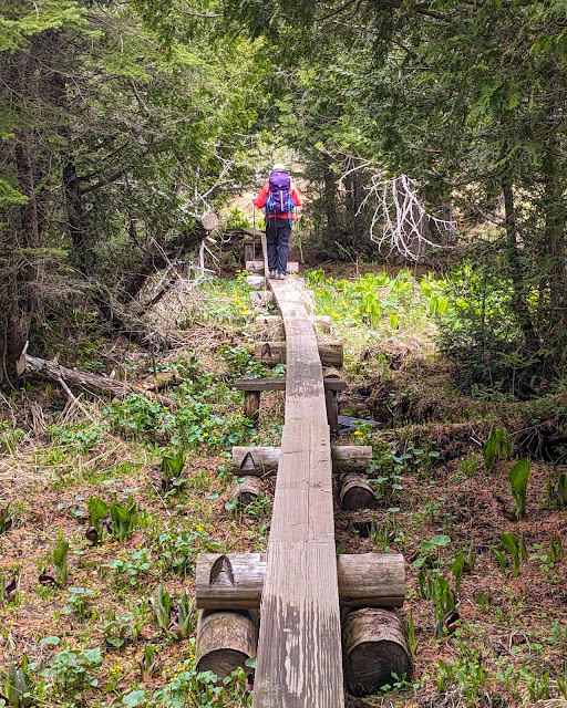 |
| A long boardwalk on the Huginnin loop |
Besides the visitor center, downtown Windigo has a number of other buildings, the best of which is a bathroom building whose toilets have running water! There are also showers and even laundry in the same building, but only the toilets were open this early in the season. There is an "old" store, and a "new" store that was being built to replace it (reputed to be opening this very year), as well as many sheds, auxiliary buildings, docks, a pavilion with electrical outlets, and even a working water fountain and spigot with potable water. The place felt more like the frontcountry than the backcountry.
Our next goal was to purchase stove fuel. Any kind of flammable gas or liquids are prohibited on the seaplane, so fliers can purchase fuel at the Windigo store -- or at least that's what the website says. The "old" Windigo store was up a short but steep trail, and it was dark, cold, and locked. The rangers were of no help, since the store is operated by a concessionaire.
A sudden rainstorm passed over us, and we took shelter under a tree along with two other people. One was our fellow flier, waiting to purchase fuel and to meet the rest of his group, and the other was some fellow who had spent the night at Washington Creek -- the nearby campground -- and wanted to buy a warmer hat from the store. He turned out to be quite talkative and kept us entertained as we waited through several more rain showers.
Some time after 10 am, a store employee appeared, huffing, puffing, and smelling strongly of a morning cigarette. She greeted us with "are you all waiting for the store?" and then continued on her slow but inexorable path up to the store, without waiting for an answer.
We followed her and found that there was only one size of gas canister available, so we bought two to be safe in the cold weather. Our fellow flier did likewise, and the person looking for a hat found something satisfactory. With that the Windigo store was closed again.
(Side note: There is quite a sharp divide between the National Park Service -- especially rangers -- and concessionaire employees. They really are almost entirely separate, even though that separation isn't obvious to visitors. The two don't always communicate well. For example, the National Park makes it clear that they do not accept cash for any payments on the island, including at the "park store". But it turned out that the concessionaire -- who runs the "Windigo store" which is not the same as the "park store" -- could only take cash because their credit card machine wasn't up and running yet. I'm glad I brought both a card and cash.)
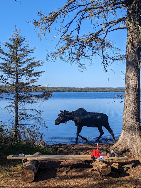
Due to rain in the forecast, which kept arriving in brief outbursts, we had decided to stay in Washington Creek campground tonight. We walked a quarter of a mile to the campground and set ourselves up at shelter #6. All of the shelters at Washington Creek are right on the creek, which is reputed to be an excellent place to watch moose. Many of the shelters were unoccupied this early in the season.
Despite deciding to sleep at Washington Creek, we didn't want to stay there all day. Our change in itinerary meant that we wouldn't have time to stay at Huginnin Cove campground, which we originally intended to be part of a two-day loop at the end of our trip. Hugininn Cove is often described as one of the more beautiful sites on the west end of the island, but it had to be cut so that we could complete the bigger Feldtmann loop. To make up for it, we decided to do the Huginnin Cove loop as a dayhike instead.
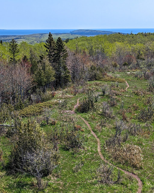
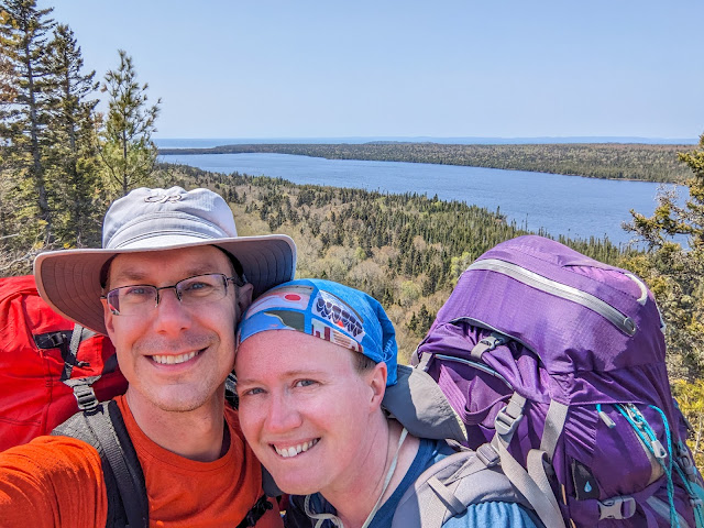
The Huginnin Cove loop has a reputation for beauty, but it's also 9.4 miles long. There was a time when we would never even think of a 9.4 mile "dayhike", much less on Isle Royale. But thanks to our Covid hobby of daily walks, we were in considerably better walking shape, so we didn't think twice about attempting the loop today.
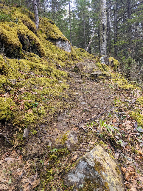 |
| Mossy East Huginnin trail |
We did the loop counterclockwise, starting with the East Huginnin trail. We first crossed Washington Creek itself, where some people in blaze orange vests were hard at work on a gauging station, an odd bit of the modern world out here in the wilderness. The East Huginnin trail was so broad and even that it must have been an old mining road. It wasn't exactly easy, but it did climb the hills as gently as could be hoped, and was remarkably wide for a backcountry trail. It barely had any roots or rocks! Even better, trail crews had clearly been this way already. We saw many places where they had sawed or moved fallen trees off of the trail, leaving a clear path for us to follow.
We soon passed the remnants of an old log cabin, with a sign pointing toward the Wendigo mine location. I popped down the side trail and found a lot of mud and a few light-gauge rails, but nothing more. Not much farther along was another cabin, several trenches, and an old exploration pit -- all things that scratched my old Copper Country Exploring itch.
Along the way, we started to notice short, stunted evergreen trees with shiny metal tags wrapped around their branches. We pondered what they might be for -- some kind of environmental study, no doubt.
The trail was wide and even, until it wasn't. As we neared the Lake Superior shore, the trail suddenly switchbacked down a steep cliff face, and we found ourselves on a more familiar type of Isle Royale trail. This trail ran on a ridge above the lake, winding over, around, and between huge boulders. Everything in sight was covered with moss. It was gorgeous, and also required all of our concentration just to walk the trail.
This is also where we saw the only snow on our trip, hiding in shady spots on the shore. When I later dipped my hand in the lake, it was probably a degree or two above freezing.
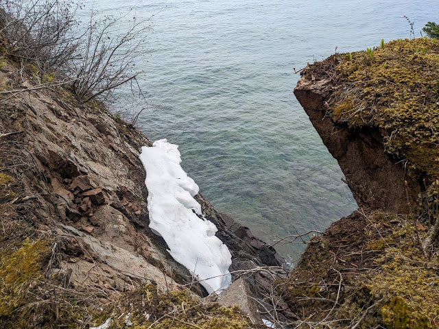 |
| Yep, that's snow |
We crossed a bridge over a bubbling creek and found ourselves at the Huginnin Cove campground. Nobody was in the campground, so we sat down in site #2 and enjoyed a nice long rest along with a lunch of rice cakes with peanut butter.
I spent some time sitting at the shore, exploring the creek and its small waterfalls, and generally enjoying a beautiful campground. The warm sun and cold wind blowing off the lake balanced each other out, and I nearly ended up taking a nap on a log bench.
We were both sad that we wouldn't be spending a night here -- that was a consequence of our reworked itinerary -- and pledged to return some time.
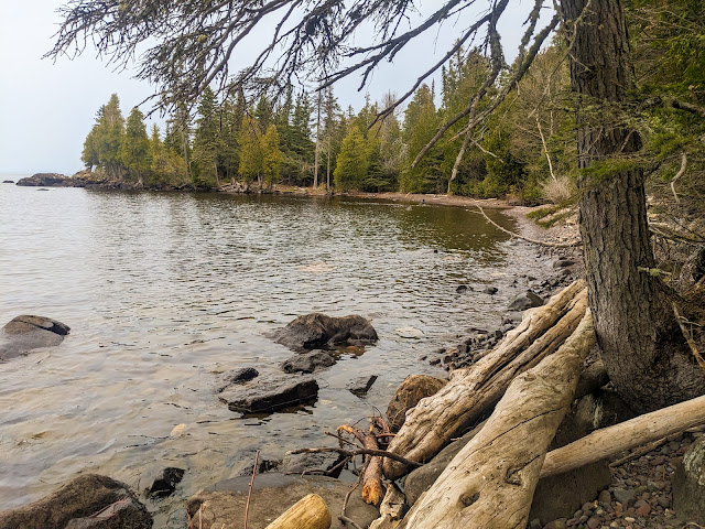 |
| Huginnin Cove from campsite #2, looking towards campsite #1 on the point |
The West Huginnin trail was a bit less joyful than the East trail. A lot of that was probably due to tired legs. This trail makes several long, slow climbs over ridges, most of it within fairly bland woods. A constant low-grade rain set in and didn't help our moods. So as we slowly slogged our way back to Windigo, we got a bit grumpy. Then we invented some rules to avoid future grumpiness. I hereby share the first draft of them with you:
- Hike your own hike - There's no need for us to hike together at the same speed or stop at the same time.
- No sniping - Be kind to each other.
- Eat something - Most grumpy hiking can be made better by stopping, taking a break, and having some food.
As we neared the end of the loop, we met the first hiker that we'd seen all day. We stopped to say hi to a woman who was walking back towards the group tent sites, and learned that she was the leader of a Moosewatch team. She enthusiastically explained the program and answered our questions. In short, volunteers (and perhaps even interns?) spend a week, often off-trail, looking for the remains of moose who have perished over the winter. Their packs famously get heavier throughout the week as they collect bones for future analysis -- how old were they? How much nutrition did they get? How did they die? It sounded fascinating, in a seriously hard core, I can barely imagine doing that kind of way. It turned out that the shiny tags on trees were also related to Moosewatch: crews were tagging Balsam firs, a moose's preferred winter food, so that their growth -- or lack thereof -- could be tracked year over year, to see how heavily moose were browsing on them.
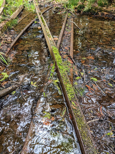 |
| Old rails at the Wendigo mine site |
Back at our shelter, we gratefully sat down at the picnic table and rested for a while. A 9.4 mile dayhike had turned out to be doable, and we were glad to have done it, but it had taken a lot out of us.
Once we were ready to move again, we made dinner: Mountain House Chicken and Dumplings, a long time favorite. Next we opened a pack of "freeze dried" peanut-butter chocolate chip cookie bites. This was a gift from some friends, and we were a bit skeptical about them -- until we tried them. They were the gift we didn't know we needed. There was no rehydrating, just small, tasty, crunchy bites. Together with hot tea, they were the perfect way to end a long, tiring, but also wonderful day.
A soaking rain had settled in as evening fell, but before bed we willingly walked all the way back in to Windigo to use the flush toilets once more! We also filled up our bottles with potable water from the faucets in the campground, another incredible luxury.
After that, we cozied up in our sleeping bags (or in my case, 0 degree down quilt). The night was cold, well into the low 30's, but that's nothing that a thermal layer, fleece, puffy coat, and warm hat couldn't handle. We hadn't set up our tents in the shelter, since we brought two tents and couldn't fit them both.
Around midnight, Sarah rolled over and said "We forgot to send a check-in message!" We'd completely forgotten to use our Garmin Messenger to send a check-in to our parents -- the main reason we'd brought it. Deciding that midnight was not the time to remedy this, we turned over and snuggled deeper into our sleeping bags.
Next time: The "Green" "stone" "ridge" - links to all of my trip logs
Miles hiked: 9.4 (Huginnin Loop) + 2.0 (back and forth to Windigo) = 11.4
Total miles: 11.4